Human Geography
Research in Human Geography at MU emphasizes the intersection of cultural identity, economic security, and place. Ethnographic examination of local communities in the context of global forces is central to these studies, whether undertaken in the Middle East, the Midwest, or western Canada (and beyond). Many of these issues cross over to the theme of Nature/Society relationships.
Readings
S.C. Larsen. (2015) Regions of care: a political ecology of reciprocal materialities. Journal of Political Ecology 23: 159-166.
M. Jacobson and S.C. Larsen. (2014) Ethnographic fiction in geographic writing and research. Journal of Cultural Geography 31(2): 179-193.
S.C. Larsen. (2016) The agency of place: toward a more-than-human geographical self. GeoHumanities 2(1): 149-166.
S.C. Larsen and J.T. Johnson. (2012) Toward an open sense of place: phenomenology, affinity, and the question of being. Annals of the Association of American Geographers 102(3): 632-646.
S.C. Larsen and C.N. Hutton (2011) Community discourse and the emerging amenity landscapes of the rural American West. Geojournaldoi:10.1007/s10708-011-9410-1.
S.C. Larsen and J.T. Johnson (2011) Towards an open sense of place: phenomenology, affinity, and the question of being. Annals of the Association of American Geographers. 102 (3).
S.C. Larsen (2008) Place making, grassroots organizing, and rural protest: A case study of Anahim Lake, British Columbia. Journal of Rural Studies 24(2): 172-181.
J. Dittmer and S.C. Larsen (2007) Captain Canuck, audience response, and the project of Canadian nationalism. Social and Cultural Geography 8(5): 737-755.
G. Riceand M.A. Urban. (2006) Where is River City, USA? Measuring community attachment to the Mississippi and Missouri Rivers. Journal of Cultural Geography 24:1-35.
S.C. Larsen (2006). The future’s past: Politics of time and territory among Dakelh First Nations of British Columbia. Geografiska Annaler 88B (3): 311-321.
M.A. Urban. (2005). An uninhabited waste: The transformation of environmental imagery and the Grand Prairie through agricultural drainage in nineteenth century Champaign County, Illinois. Journal of Historical Geography 31(4): 647-665.
J.J. Hobbs (2005) The Geographic Dimensions of Al-Qa’ida Rhetoric. Geographical Review 95(3):301-327.
S.C. Larsen (2004) Place identity in a resource-dependent area of northern British Columbia. Annals of the Association of American Geographers 94(4): 944-960.
J.J. Hobbs (1995) Mount Sinai. Austin: University of Texas Press.
S.C. Larsen and J.T. Johnson. (2017) Being Together in Place: Indigenous Coexistence in a More Than Human World. University of Minnesota Press.
J. Hobbs. (2017) Heritage in the Lived Environment of the United Arab Emirates and the Middle East Regions. International Journal of Architectural Research.
J. Hobbs. (2017) Islamic Geography and Cartography in The [Oxford] Encyclopedia of Philosophy, Science, and Technology in Islam.
M. Palmer. (2016) Sustaining Indigenous Geographies through World Heritage: A Study of Uluru-Kata Tjuta National Park. Sustainability Science 11(1): 13-24.
M. Palmer. (2016) Kiowa Storytelling around a Map. In C. Travis and A. van Lunen (Ed.), The Digital Arts and Humanities: Neogeography, Social Media and Big Data Integration and Applications (Dordrecht, NLD: Springer Publishing), pp. 63-73.
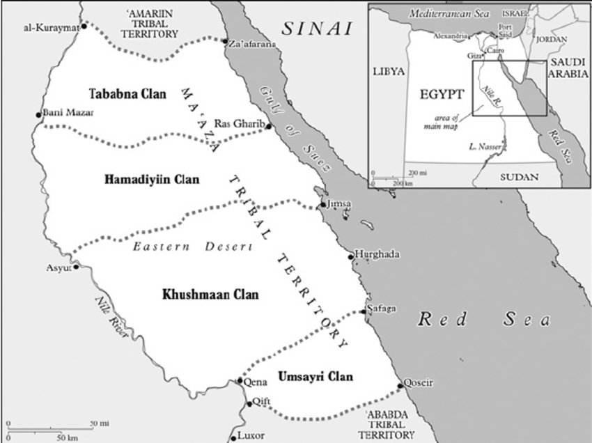
J. Hobbs. (2014) Bedouin Place Names in the Eastern Desert of Egypt. In Dawn Chatty, ed. Reshaping Tribal Identities in the contemporary Arab World: Politics, Self-Representation, and the Construction of Bedouin History. Nomadic Peoples Special Issue 18(2): 123-146.
D. Hurt. (2014) Cartographic Influences on the Shaping of a Creek (Muscogee) Homeland in Indian Territory. In Mapping Native America: Cartographic Interactions between Indigenous Peoples, Government, and Academia, Volume II, ed. Daniel G. Cole and Imre Sutton, pp. 67-94. Charleston, S.C.: CreateSpace.
M. Palmer. (2013) (In)digitizing Cáuigú Historical Geographies: Technoscience as a Postcolonial Discourse. In A. von Lunen and C. Travis (Ed.), History and GIS: Epistemologies, Considerations and Reflections, (Dordrecht, NLD: Springer Publishing), pp. 39-58.
M. Palmer. (2013) Cartographic Encounters with the Bureau of Indian Affairs’ GIS. In D. Cole and I. Sutton (Ed.), Mapping Native America: Cartographic Interactions between Indigenous Peoples, Government, and Academia, (modified reprint of Palmer, M. 2012, AICRJ article).
J.T. Johnson and S.C. Larsen, eds (2013) A Deeper Sense of Place: Stories and Journeys of Collaboration in Indigenous Research. Corvallis: Oregon State University Press.
S.C. Larsen. (2013) The micropolitics of storytelling in Indigenous research: reflections on a mapping project with the Cheslatta-Carrier Nation in British Columbia. In A Deeper Sense of Place: Stories and Journeys of Collaboration in Indigenous Research, ed. Jay T. Johnson and Soren C. Larsen. Corvallis: Oregon State University Press.
M. Palmer, and R. Rundstrom. (2012) GIS, Internal Colonialism, and the U.S. Bureau of Indian Affairs. Annals of the Association of American Geographers 103(5): 1142-1159
S.C. Larsen and J.T. Johnson, eds (2012) In Between Worlds: Place, Experience, and Research in Indigenous Geography. Journal of Cultural Geography, 29 (1).
M. Palmer. (2012) Cartographic Encounters at the BIA GIS Center of Calculation. American Indian Culture and Research Journal 36(2) 75-102.
M. Palmer. (2012) Theorizing Indigital Geographic Information Networks. Cartographica: The International Journal for Geographic Information and Geovisualization 47(2): 80-91.
J. Hobbs. (2012) Ritual Uses of Caves in West Malaysia. In Sacred Darkness: A Global Perspective on the Ritual Use of Caves, edited by Holley Moyes. Boulder: University Press of Colorado, pp. 331-341.
M. Palmer (2011) Sold! The loss of Kiowa allotments in the post-Indian Reorganization era. American Indian Culture and Research Journal 35(3).
M. Palmer (2011) Centralized Geographic Information System development at the Bureau of Indian Affairs in the late twentieth century. In Mapping Native America: Cartographic Interactions between Indigenous Peoples and Government and Academia, ed. Dan Cole and Imre Sutton. Washington, DC: Smithsonian Institution Scholarly Press.
J. Dittmer and S.C. Larsen (2010) Aboriginality and the Arctic North in Canadian nationalist superhero comics, 1940-2004. Historical Geography 38: 52-69.
J. Hobbs and F. Tsunemi (2007) Soft Sedentarization: Bedouin Tourist Stations as a Response to Drought in Egypt’s Eastern Desert. Human Ecology 35 (2).
S.C. Larsen (2006) The future’s past: Politics of time and territory among Dakelh First Nations of British Columbia. Geografiska Annaler88B (3): 311-321.
J. Hobbs (2005) Guidelines for the Involvement of Pastoral Nomads in Conservation and Development Efforts. In Dawn Chatty, ed. Nomadic Societies in the Middle East and North Africa: Entering the 21st Century. Leiden: E.J. Brill, pp. 785-201.
D. Hurt, and M.L. Wallace. (2005) Teaching American Indian Geography and History with New Perspectives: The Lodge Pole River Project Example. Journal of Geography 104(5): 187-193.
D. Hurt. (2003) Defining American Homelands: A Creek Nation Example, 1828-1907. Journal of Cultural Geography 21(1): 19-43.
S.C. Larsen (2003) Collaboration geographies: Native-White partnerships during the resettlement of Ootsa Lake, British Columbia, 1900-52. BC Studies 138-139: 87-114.
J. Hobbs (2001) Exploration and Discovery With the Bedouin of Egypt. Geographical Review 91:1-10.
Foulkes, M. and Schafft, K. (2010) The impact of migration on poverty concentrations in the United States, 1995-2000. Rural Sociology 75(1): 90-110.
Foulkes, M. and Newbold, K.B. (2008) Poverty catchments: migration, residential mobility, and population turnover in impoverished rural Illinois communities. Rural Sociology 73: 440-462.
Foulkes, M., Hermson, J., Raedeke, N., and Rikoon, S. (2008) Missouri Hunger Atlas. Interdisciplinary Center for Food Security.
Foulkes M, Newbold K B. (2005) Geographic mobility and residential instability in impoverished rural Illinois places. Environment and Planning A 37: 845 – 860.
Foulkes, M.W. and Newbold, K. B. (2000) Migration propensities, patterns, and the role of human capital: Comparing Mexican, Cuban, and Puerto Rican Interstate Migration, 1985-1990. The Professional Geographer 52: 133-145.
D. Hurt. 2018. Baseball Stadiums and Urban Reimaging in St. Louis: Shaping Place and Placelessness. In Explorations in PLACE Attachment, ed. Jeffrey S. Smith. London: Routledge.
A. Payne and D. Hurt. 2015. Narratives of the Mother Road: Geographic Themes Along Route 66. Geographical Review 105(3): 283-303.
J. Widener with D. Hurt. (2013) The Starbucks Experience: Percolations from Mexico and the United States. Illinois Geographer 55(2): 17-42.
D. Hurt, A. Delvecki, A. Payne, and G. Gress. (2012) Oklahoma Tourism Along Route 66: Pioneers, Perseverance, Community and Freedom. Material Culture 44(1): 31-49.
J.S. Smith and D. Hurt. (2011) Roads Less Traveled: Emerging Tourism in Peru. FOCUS on Geography 54(1): 11-23
D. Hurt. (2010) Reinterpreting the Washita Battlefield National Historic Site. Geographical Review 100(3): 375-393.
D. Hurt. (2010) Highway Expansion and Landscape Change in East Tennessee. FOCUS on Geography 53(2): 72-80.
D. Hurt. (2006) Teaching and Research in Historical Geography: A Survey of U.S. Practitioners. Historical Geography 34: 71-85.
D. Hurt. (2005) Dialed In?: Geographic Expansion and Regional Identity in NASCAR’s Nextel Cup Series. Southeastern Geographer 45(1): 120-137.